


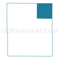
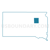
VTD-precinct 8, Spink County, South Dakota
About
Outline

Summary
| Unique Area Identifier | 667775 |
| Name | VTD-precinct 8 |
| County | Spink County |
| State | South Dakota |
| Area (square miles) | 143.63 |
| Land Area (square miles) | 143.62 |
| Water Area (square miles) | 0.01 |
| % of Land Area | 99.99 |
| % of Water Area | 0.01 |
| Latitude of the Internal Point | 45.15351760 |
| Longtitude of the Internal Point | -98.10022210 |
Maps

Graphs
Select a template below for downloading or customizing gragh for VTD-precinct 8, Spink County, South Dakota


Neighbors
Neighoring Voting District (by Name) Neighboring Voting District on the Map
- VTD-precinct 1, Clark County, SD
- VTD-precinct 1, Spink County, SD
- VTD-precinct 19, Brown County, SD
- VTD-precinct 2, Clark County, SD
- VTD-precinct 7, Spink County, SD
- VTD-precinct LT Sld-OG-Vy-Ty-Blr-Yk-Btltn-LilyTwn, Day County, SD
Top 10 Neighboring County Subdivision (by Population) Neighboring County Subdivision on the Map
- Garden Prairie township, Brown County, SD (188)
- Conde city, Spink County, SD (140)
- Tetonka township, Spink County, SD (58)
- Bates township, Brown County, SD (42)
- La Prairie township, Spink County, SD (40)
- Warren township, Clark County, SD (38)
- Scotland township, Day County, SD (34)
- Ash township, Clark County, SD (32)
- Olean township, Spink County, SD (31)
- Beotia township, Spink County, SD (31)
Top 10 Neighboring Place (by Population) Neighboring Place on the Map
Top 10 Neighboring Unified School District (by Population) Neighboring Unified School District on the Map
- Groton Area School District 06-6, SD (3,587)
- Northwestern Area School District 56-7, SD (1,800)
- Doland School District 56-2, SD (849)
Top 10 Neighboring State Legislative District Lower Chamber (by Population) Neighboring State Legislative District Lower Chamber on the Map
- State House District 2, SD (21,657)
- State House District 1, SD (20,515)
- State House District 6, SD (19,896)
Top 10 Neighboring State Legislative District Upper Chamber (by Population) Neighboring State Legislative District Upper Chamber on the Map
- State Senate District 2, SD (21,657)
- State Senate District 1, SD (20,515)
- State Senate District 6, SD (19,896)
Top 10 Neighboring 111th Congressional District (by Population) Neighboring 111th Congressional District on the Map
Top 10 Neighboring Census Tract (by Population) Neighboring Census Tract on the Map
- Census Tract 9558, Clark County, SD (3,691)
- Census Tract 9519, Brown County, SD (3,530)
- Census Tract 3, Spink County, SD (1,786)
- Census Tract 9527, Day County, SD (1,682)